


Discover how to use maps as a key part of your family history research to plot where your ancestors lived and worked, to discover crucial clues and to make so much more sense of your family history findings. Using historical maps is a truly useful way to visualise the evidence, identify clues - and find research solutions.
The best map websites for family history
How to use Ordnance Survey maps for family history
Case study: How to map a family network
Case study: Top tips for using maps in street history
Case study: Get a Gold Rush map!
The best map websites for family history
Trace your ancestors through time and place with our guide to the best map-related websites for tracing your family tree online.
Whether you’re new to family history or have been tracing your tree for many years, at some point a historical map website is sure to be of use. Not only can a maps website help you to follow the movements of your ancestors over the decades, you could also discover:
- How areas have changed over the years
- How built-up the area where you ancestor lived was at a certain time
- The social and economic make-up of the area
- How war affected our ancestors
- Where particular landmarks/streets were located within a settlement
NLS maps
NLS Maps is run by National Library of Scotland but despite the name, covers England, Scotland and Wales. It contains vast collections of Ordnance Survey (OS) maps spanning the 1820s-1970s. You can also browse by map maker, or drill into specialist maps such as the Royal Military Maps of Scotland (created in the aftermath of Culloden).
TheGenealogist's Map Explorer
TheGenealogist is a subscription website that provides access to a growing range of map collections such as:
- the Tithe Maps and field books;
- Lloyd George Domesday maps;
- Charles Booth Poverty maps;
- Ordnance Survey maps;
- and modern day maps.
The unique Map Explorer tool from TheGenealogist enables you to search on modern day or historic locations, track pinned locations through the eras, and link from the census to a map to see the whereabouts of a property, working backwards or forwards through time using the range of mapping resources available on the website. Mark Bayley is technical lead at TheGenealogist and his video below, covering TheGenealogist's Map Explorer, was recorded in 2021.
A Vision of Britain Through Time
A Vision of Britain Through Time is a website covering Britain from 1801 through to the present day with maps, statistical trends and historical descriptions.
- The site is also the home of the GB1900 gazetteer, with 2.5 million place names and other information from early six-inch maps of Britain.
- Within the historical maps section there are three sections: topographic (physical landscape), boundary (showing boundaries of parishes, councils etc) and land use maps (what each parcel of land has been used for).
Britain From Above
Britain From Above features images from the Aerofilms Collection of aerial images covering the years 1916 to 2006 and comprising more than 1.26 million negatives.
- The images feature coastal, urban, rural, and industrial areas and show how Britain changed during the course of the 20th century.
- You can search by area, town or city name or narrow down to the level of a particular district/suburb/landmark
- There are also options to download, buy or ‘pin’ maps, with the latter allowing you to add your own notes and observations about a particular map.
British History Online
British History Online is a digital collection of resources including historical maps, focusing on the period 1300 to 1800.
- The maps section can be found via the home page and here you can explore maps including England, Ireland, Scotland and Wales.
- One of the most fascinating and rare resources is a 1667 survey of the city of London after the fire of 1666 and this can be found here.
Charles Booth’s London - poverty map
The poverty map on Charles Booth’s London are part of an archive of 450 volumes from the UNESCO-recognised Inquiry into the Life and Labour of the People in London by Charles Booth, an industrialist and social reformer.
- The project documents the social and economic life of London between 1886 and 1903, particularly highlighting those areas where contrast existed.
- You can either search or browse for a present-day location and then compare this to Booth’s Map of London. Alternatively simply search or browse the historical map by zooming in on places of interest.
- You can also compare places on the historical map to the present day situation.
- The colour legend shows how the various areas were classified, ranging from ‘lowest class, vicious semi-criminal, to ‘upper middle and upper classes, wealthy’. Seeing how these extremes are often within streets of each other is very interesting.
- PS - not maps, but don't miss the notebooks too, which make for fascinating reading including interviews with inhabitants.
Griffith’s Valuation
Griffith’s Valuation was the first full-scale valuation of property in Ireland and was published between 1847 and 1864. It is considered one of them most valuable surviving genealogical sources of the 19th century.
- The maps present the six-inch series created at the time of Griffith's Valuation during the nineteenth century, including the dividing lines between valuations.
- The maps include historical town plans, name books (showing place name details and variants) and the six-inch series maps. You can find guides to search by place name and family name here.
History Pin
History Pin was established as a place for people to share historic photos and stories, and so has maps at its heart and uses these as a basis for exploring the resources and tales.
- Start by searching for a town, street or landmark and then look at the pins for that area. These can include photos, family history information and local knowledge.
- You can also add your own pins to help grow the project and as a record of your own ancestors and the places they lived and worked.
Old Maps Online
Old Maps Online offers the facility to enter a modern-day place name and you can view up to 350 map layers a month for free; subsequent searches are subject to a subscription payment.
Once you’re typed your place of interest into the search box you’ll be given a list of available maps and can then either explore online or buy the map in question. Many of the maps are extremely detailed, going down to the level of the location of a drinking fountain, for example.
Proni Historical Maps
Public Record Office of Northern Ireland Historical Maps comprise a collection of maps showing county, parish and townland boundaries, as well as information on sites, buildings and landmarks.
- The historical maps are from the six-inch counties series mapping and cover the six counties of present-day Northern Ireland: counties Antrim, Armagh, Down, Fermanagh, Londonderry and Tyrone.
Tithe Maps of Wales
Tithe Maps of Wales is the place to search and browse 300,000 locations in Wales using this free online collection of digitised historic tithe maps and accompanying apportionment documents.
England Jurisdictions 1851
England Jurisdictions 1851 maps the administrative boundaries for places across in England and Wales. This is useful as it shows you the size and location of your parish of interest, for instance, and also enables you to see the names of the neighbouring parishes.
Irish Townland Maps
Irish Townlands provides detailed information and map coverage for townlands in Ireland. This is very useful as a townland is the smaller administrative unit in Ireland. As such, if you can identify which townland your ancestors came from, you will know with great precision your ancestral origins in the Emerald Isle.
How to use Ordnance Survey maps for family history
Find out how to use old maps for family tree research with advice from Elaine Owens, creator of historical mapping innovations such as Geovation and Timepix. Here she speaks about using paper Ordnance Survey maps, but the symbols and many of the search tips and clues are the same whether using print or digital iterations of the OS maps.
Get to know the area
Choose an area where you have lots of relatives, fully unfold the map and just immerse yourself in looking at the countryside.
Place names you have found in the records will start to jump out at you and you should also find farm names, see the big landed estates and generally begin to form an impression of the character of the villages and towns which shaped your ancestors' lives.
Places of worship have different symbols according to whether they have a tower, a spire or neither. The first church for any settlement would be built in a dominant position near the original centre. Places of worship without a spire or tower are more likely to be later and to be Nonconformist chapels.
Understand distance
How might your relatives have travelled around?
- Each grid square on a 1:50,000 scale map is 1km across which takes an average of 10 minutes to walk. By horse and cart that distance might still take 7 minutes.
- The route of disused railways lines can also often be seen on the modern map.
- So consider where might they have gone to school, or found entertainment, or shopped when they needed something more than everyday food?
1:25000 Explorer maps
The Explorer maps at 1:25000 scale show much more detail about land cover and use.
- You can see the patterns of houses and that the more prosperous areas have bigger gardens, are more spaciously laid out and are less likely to be right next to industrial areas, sewage works and other potentially undesirable features.
- Motorised transport allowed people to live away from the town centres, but fares cost money so moving further out might mean your relatives were getting better off.
- Landowners sold off fields either when tempted, or obliged to, and you can often clearly see the old field boundaries preserved in new housing estates.
- In rural areas fields are still shown on the map as well as paths and tracks and names of many of the smaller farms are shown at this scale.
- You can also find evidence of old workings for stone, sand, lime and other materials which may tie up with the occupations listed for your ancestors in the census.
Find out more about Ordnance Survey maps here.
The advice from Elaine Owens was originally published July 2016. Reviewed 05 February 2026.
Case study: How to map a family network
Researcher Wayne Shepheard combined parish registers and 19th century maps and plotted details for a number of his family members in London in the early 19th century, to help him work out the family network and clarify the many possible connections between the individuals. Here's how he got on.
‘We all know that when you are tracing ancestors it can help to source information about close relatives, friends or neighbours to see whether they worked, attended church or moved to other places together,’ writes researcher Wayne Shepheard.
‘In densely populated areas such as London, it is never easy to know for sure where people might have lived, how long they were there, what their occupation was, where they went to church or who their friends were. If both forenames and surnames are common, identifying individuals can be confusing…’
Faced with this predicament, Wayne decided to look at a variety of documents and then to maps to plot:
- where events occurred
- & where people lived.
He hoped that this would help him search correctly for his family members.
How did Wayne map his family history research?
- Wayne put together a map that showed where certain events (such as baptisms, marriages, burials) took place,.
- He also noted which addresses were given for businesses or residences in apprenticeship agreements, directories and land tax lists.
- Lastly, he also explored wills – as these usefully contained the names of family members, and information about locations where individuals lived.
- Wayne then chose a colour for each family group (blue for the Tunstalls, green for the Mayfields, red for the Auchterlonys, and yellow for the Mayfield-Tunstalls).
- Lastly he also provided a numerical key – explaining precisely to whom a mark on the map pertained. E.g.
- 1755 apprenticeship agreement of Anthony Tunstall with master George Ball, of St Andrew, Holborn (cabinet maker)
- 1762 marriage of Anthony Tunstall & Eleanor Keap – St Anne & St Agnes church, Gresham St
Tip: get a map relevant to the time of your research
Map often prove very useful in finding streets that no longer exist, having since been built over, or bombed during World War II. If you choose a map that was produced around the time frame of families that are the focus of your research, then you will gain a contemporaneous record of their locality. For Wayne’s family, the map he chose was Edward Mogg’s 1806 London in Miniature with the Surrounding Villages Entire New Plan map.
To read Wayne Shepheard's full account of his family history mapping project see the June 2024 issue of Family Tree (available as a digital purchase here, or available as part of your Family Tree Plus member library).
Case study: Top tips for using maps in street history
Paul Bishop, chair of the Scottish Local History Forum, shares his tips on comparing and contrasting old and new maps to get an idea of how your street has changed over the years.
My top tip for street history is to use the National Library of Scotland (NLS) maps website. The site has many old maps, dating right back to the earliest mapping of Scotland, but these early maps won’t be useful for individual streets.
Therefore, the best bets for this are:
- Estate Maps - The NLS might have scanned an estate map that includes your house – mine is on a farm plan from an 1805 set of estate plans.
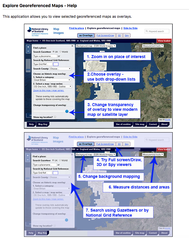
- Ordnance Survey Maps - With Ordnance Survey maps and using the ‘Explore georeferenced maps’ feature on the NLS maps website here, you can overlay old OS maps dating from the late 19th century onto a modern aerial image and slide between them seeing how your street and your house might have changed (or what was there before, if your street is more recent than the late 19th century).
Combining maps and directories - Your map research can be combined with searching local Post Office Directories. They can be searched by place, year and resident’s name – a veritable gold mine of information.
Case study: Get a Gold Rush map!
Maps tell so many stories. To finish our guide, below is a fascinating map showing possible routes that would-be gold prospectors might take to make their way out west to Oregon at the height of the Gold Rush.
Gold prospecting is just one of many reasons that our ancestors may have left Britain and Ireland, and why you may have roots that can be traced back to these shores today.
Folded into the back of Disturnell’s Guide to New-Mexico, California & Oregon the map shown below details the possible routes that would-be gold prospectors might take to make their way out west to Oregon - to reach the gold fields in the least possible time (it's a Gold Rush, right?!).
Guides and maps such as this were published to help people find out about the practicalities of their proposed venture. Such guides covered, in great detail, lists of what people needed to pack for the journey, information to help them plan their own route west, etc. We’re sharing the map with you here so that you can enjoy poring over it - to view a Zoomable version please view it on Archive.org here.
