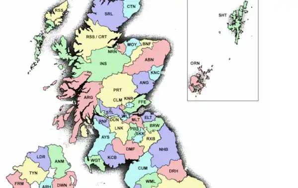
This counties map from The Historic Counties Trust shows the names and areas of the historic Scottish counties - or shire - as well as the counties of England, Wales and Northern Ireland.
The Historic County Borders Project digitised the borders of the historic counties of the UK and has made them freely available for public and commercial use.
The project is closely based on the Historic Counties Standard, which provides a comprehensive definition of the names, areas and borders of the historic counties of the UK.
A history of counties/shires in Scotland
Historically, Scotland was administered in units of burghs and parishes, however after 1889, counties (also known as shires) were introduced alongside large and small burghs and counties of cities. Between 1975 and 1996, Scotland was divided into regions and districts (with separate island areas).
If you're searching for your Scottish ancestors, you'll find the relevant records much easier to use if you have an understanding of the pre-1890 counties/shires and the changes that took place as a result of the Local Government (Scotland) Act 1889.
ScotlandsPeople has a helpful guide to history counties, cities and burghs.
Scotland is currently divided into 33 registration counties.
.gif)
HCS Historic County Code ABN Aberdeenshire AGL Anglesey ANG Angus ANM Antrim ARG Argyllshire ARH Armagh AYS Ayrshire BNF Banffshire BED Bedfordshire BER Berkshire BRW Berwickshire BRN Brecknockshire BUC Buckinghamshire BTE Buteshire CRN Caernarfonshire CTN Caithness CMB Cambridgeshire CRD Cardiganshire CRM Carmarthenshire CHE Cheshire CLM Clackmannanshire CNW Cornwall CRT Cromartyshire CUM Cumberland DBH Denbighshire DRB Derbyshire DVN Devon DRS Dorset DWN Down DMF Dumfriesshire DUN Dunbartonshire |
HCS Historic County Code DRH Durham ELT East Lothian ESE Essex FRM Fermanagh FFE Fife FLT Flintshire GLM Glamorgan GLC Gloucestershire HMP Hampshire HRF Herefordshire HTF Hertfordshire HNT Huntingdonshire INS Inverness-shire KNT Kent KNC Kincardineshire KNR Kinross-shire KCB Kirkcudbrightshire LNK Lanarkshire LCS Lancashire LCR Leicestershire LNC Lincolnshire LDR Londonderry MRN Merionethshire MSX Middlesex MLT Midlothian MNM Monmouthshire MTG Montgomeryshire MOY Morayshire NRN Nairnshire NRF Norfolk NHP Northamptonshire |
HCS Historic County Code NHB Northumberland NOT Nottinghamshire ORN Orkney OXD Oxfordshire PBS Peeblesshire PMB Pembrokeshire PRT Perthshire RDN Radnorshire RNF Renfrewshire RSS Ross-shire RXB Roxburghshire RTL Rutland SKK Selkirkshire SHT Shetland SHP Shropshire SMS Somerset STF Staffordshire STL Stirlingshire SFF Suffolk SUR Surrey SUS Sussex SRL Sutherland TYN Tyrone WRW Warwickshire WLT West Lothian WML Westmorland WGT Wigtownshire WTS Wiltshire WRC Worcestershire YRK Yorkshire |
What is the Historic Counties Standard?
By providing a definition for the terminology and the names, areas and borders of the historic counties, the Standard will enable a more consistent use of the historic counties to be made in those numerous contexts for which they are the most natural geographical framework, principally in the fields of history, geography, heritage and education. For example:
- In the organisation, indexing and cataloguing of historical documents and artefacts;
- In descriptions of the location of historical events;
- In local history studies (e.g. place name surveys, county histories etc.);
- In historical geography (e.g. studies of changes in demography, land-use etc.);
- In the presentation to the public (e.g. in museums, libraries, record offices etc.) of material relating to history;
- In family history publications and data sources;
- In educational maps and publications;
- In the classification and cataloguing of ancient and historical monuments and buildings, and in publications describing these.
Map and information courtesy of the Historic Country Borders Project.


