Find out how to use old maps for family tree research with Elaine Owens.
Paper maps remain the best way to get a proper overview of a landscape and the best known OS maps are the Landranger series at 1:50000 scale. This is the nearest modern equivalent to the old 1-inch map.
Get to know the area
Choose an area where you have lots of relatives, fully unfold the map and just immerse yourself in looking at the countryside. Place names you have found in the records will start to jump out at you and you should also find farm names, see the big landed estates and generally begin to form an impression of the character of the villages and towns which shaped your ancestors' lives.
Places of worship have different symbols according to whether they have a tower, a spire or neither. The first church for any settlement would be built in a dominant position near the original centre. Places of worship without a spire or tower are more likely to be later and to be Nonconformist chapels.
Understand distance
How might your relatives have travelled around? Each grid square on the map is 1km across which takes an average of 10 minutes to walk. By horse and cart that distance might still take 7 minutes. The route of disused railways lines can also often be seen on the modern map. So consider where might they have gone to school, or found entertainment, or shopped when they needed something more than everyday food?
1:25000 Explorer maps
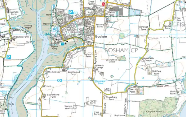
The Explorer maps at 1:25000 scale show much more detail about land cover and use. You can see the patterns of houses and that the more prosperous areas have bigger gardens, are more spaciously laid out and are less likely to be right next to industrial areas, sewage works and other potentially undesirable features. Motorised transport allowed people to live away from the town centres, but fares cost money so moving further out might mean your relatives were getting better off.
Landowners sold off fields either when tempted, or obliged to, and you can often clearly see the old field boundaries preserved in new housing estates. In rural areas fields are still shown on the map as well as paths and tracks and names of many of the smaller farms are shown at this scale. You can also find evidence of old workings for stone, sand, lime and other materials which may tie up with the occupations listed for your ancestors in the census.
Free online maps
But, don’t ignore computer maps. The new online service called OS Maps allows you to explore the whole of GB using free ‘standard’ maps that have some really useful features for family historians. Search is by by postcode or street address, as well as place names. Once at your chosen location zoom in as far as you can and you will see that the street names are all here, plus building outlines, tracks and field boundaries. This level of detail is often lacking in other free online mapping services, especially in rural areas, so it is well worth checking out this free service.
Upgrade for more detail
If you are willing to pay, then OS Maps can provide a lot more, including access to all Explorer and Landranger maps, and aerial photography for the whole of Great Britain. With the paid service you can make unlimited print outs at A4 or A3 and the quiet colour tones of the zoomed in maps are perfect for writing your own notes and annotations on the paper copies. You can also take OS maps with you on a smartphone to make sure you don’t get lost when you go exploring the by-ways of where your family once lived.
OS Maps allows you to create a route. This is intended for planning a walk, run or cycle ride, but a family historian can use it to recreate a route their ancestor may have walked and it will calculate how long that would have taken them. Wouldn’t it be wonderful if travel calculators were also included for transport by horse and cart!
Find out more about Ordnance Survey maps here.
Elaine Owens is Ordnance Survey’s School Sector Manager, working in education to create a GI literate generation. In addition to this, through Geovation, Elaine has created a prototype that she hopes will help people look at genealogy and historical material in a whole new way.
Originally published July 2016. Reviewed May 2023.


